Latest release

Significant Urban Areas, Urban Centres and Localities, Section of State

Australian Statistical Geography Standard (ASGS) Edition 3
Reference period
July 2021 - June 2026

The Australian Statistical Geography Standard (ASGS) classifies urban areas in several different ways to make a wide range of statistical data available for Australian towns and cities. All classifications of urban areas created by the ABS are for the purpose of statistical analysis and do not match official legal or administrative boundaries.

  • Each Significant Urban Area (SUA) represents an individual Urban Centre or cluster of related Urban Centres with a core urban population over 10,000 people.
  • The Urban Centre and Locality (UCL) classification is aggregated from Statistical Areas Level 1 (SA1) which meet population density criteria or contain urban infrastructure.
  • Section of State (SOS) groups the UCLs into classes of urban areas based on population size, and the remainder is considered to be rural.
  • Section of State Range (SOSR) provides a more detailed classification than SOS. This enables statistical comparison of differently sized Urban Centres and rural areas.

The ASGS Edition 3 Significant Urban Areas, Urban Centres and Localities and Section of State were developed using population and dwelling data from the 2021 Census of Population and Housing. The next update will be after the 2026 Census of Population and Housing.

For information on how Significant Urban Areas, Urban Centres and Localities and Section of State relate to the whole ASGS, refer to the ASGS diagram.

Urban Centres and Localities

Urban Centres and Localities (UCLs) represent areas of concentrated urban development. They are identified using dwelling and population density criteria and data from the 2021 Census of Population and Housing. 

Urban Centres and Localities are designed to facilitate the visualisation and analysis of statistical data, in particular data from the Census of Population and Housing. The criteria for inclusion (such as minimum population sizes) enable users to access cross classified Census data (such as population counts by various age ranges), without limiting the usability of the associated data. 

The ABS does not produce an official list of towns and cities in Australia. Please refer to state and territory lists of gazetted localities for this information. Urban Centres and Localities are not an official definition of towns and cities for several reasons. Firstly, small towns that do not meet the minimum population criteria are allocated to Remainder of State/Territory in this classification. Additionally, urban settlements near each other may be combined under one name. For example, several towns are grouped together in the Urban Centre of Central Coast. Towns and cities not included in Urban Centres and Localities may be represented by other geographies such as Statistical Areas Level 2 or approximated Suburbs and Localities.

UCL design criteria

Urban Centres and Localities (UCLs) are defined using Statistical Areas Level 1 (SA1s) that meet density and/or urban infrastructure criteria.

Areas not within Urban Centres or Localities are labelled as Remainder of State/Territory and considered to be rural for the purpose of statistical analysis. In combination with Remainder of State/Territory areas, Urban Centres and Localities cover the whole of Australia without gaps or overlaps.

Where urban areas cross state or territory boundaries, Urban Centres are split into two parts so that they can be aggregated up to the state or territory level. However, cross border Urban Centres are considered to be one unit for design purposes – for example, Albury - Wodonga.

Defining urban Statistical Areas Level 1

Population and dwelling density criteria

Statistical Areas Level 1 (SA1s) are considered urban if they meet one or more of the following criteria:

  • The SA1 has an urban Mesh Block* population greater than or equal to 45% of the total SA1 population^ and a dwelling density greater than or equal to 45 dwellings per square (sq) kilometre (km).
  • The SA1 has a population density greater than or equal to 100 persons per sq km and a dwelling density greater than or equal to 50 dwellings per sq km.
  • The SA1 has a population density greater than or equal to 200 persons per sq km.

*An urban Mesh Block is defined as a Mesh Block with a population density of 200 persons or more per sq km.
^The population and dwelling figures used for these criteria are Place of Usual Residence from the 2021 Census of Population and Housing.
 

Urban infrastructure criteria

SA1s may also be considered urban if they are adjacent to another SA1 that meets the population and dwelling density criteria and also contain substantial urban infrastructure or land use, as defined below.

Note that SA1s meeting at a point are not considered to be adjacent.

Urban infrastructure

Not urban infrastructure

Urban Centre criteria

Adjacent urban SA1s are combined to form Urban Centres if they meet the following requirements:

  • The aggregated population of urban SA1s is 1,000 persons or more
  • The combined urban SA1s have an urban identity, meaning shared urban facilities of some kind and an identifiable name

Discrete Aboriginal and Torres Strait Islander communities and discrete tourist resorts with a population exceeding 1,000 are considered to be Urban Centres regardless of density.

A military base or prison cannot be an Urban Centre in its own right.

State or territory borders, Local Government Areas (LGA) and other administrative boundaries are not considered in determining whether an SA1 should be included within the Urban Centre.

Non-urban SA1s may be included in an Urban Centre for three reasons.

  1. An SA1 is completely surrounded by urban SA1s belonging to the same Urban Centre. This includes areas that are bounded by an Urban Centre and a shore or coastline.
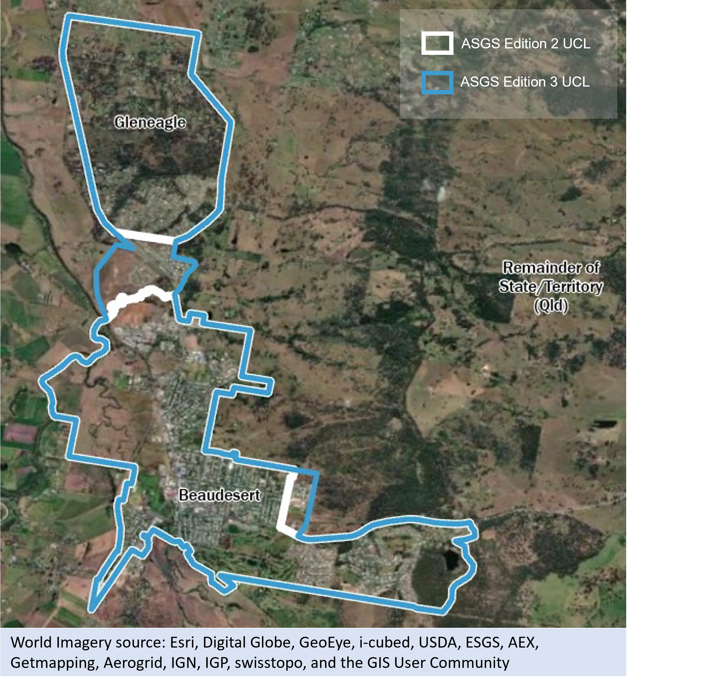
  2. An SA1 is acting as a bridge between an Urban Centre and a nearby urban SA1 that is within 500 metres road distance and could reasonably be regarded as part of that Urban Centre.
  3. An SA1 is on the edge of an Urban Centre and contains high density development, or urban infrastructure as well as rural land.

In each of these cases, discretion is applied when factoring in the overall design of the Urban Centre, especially the effect the inclusion of the non-urban SA1 will have on the overall population density of that Urban Centre. In rare instances, discretion may also be applied to other Urban Centre criteria to maintain stability over time.

Both SA1s and Mesh Blocks are designed to reflect the edge of urban areas. However, there are some cases where the other design criteria for these areas, such as population size or alignment to gazetted Suburb and Locality boundaries, may compromise this. As a result some SA1s may contain urban settlement or infrastructure but not meet the urban SA1 criteria.

Urban Centres with a population of 20,000 people or more are combined with any other Urban Centre within 3km. This distance is calculated along sealed roads between the edge of the closest urban Mesh Blocks, or adjoining urban infrastructure and land use, within each Urban Centre. SA1s containing the shortest road route between the two clusters are also included to bridge them together, unless they severely compromise Urban Centre design. Ferry and rail links are not considered.

Adjacent Urban Centres are not combined and are considered separate if:

  • they are separated by an un-bridged geographical barrier, such as a river, escarpment, inlet, lake or swamp
  • the Urban Centres represent separate labour markets (defined as: a single GCCSA or the combined SA4s of Newcastle and Lake Macquarie and Hunter Valley exc Newcastle, as these represent a single labour market)


Locality criteria

Localities represent smaller discrete settlements with populations generally between 200 and 999 people.  Localities are diverse, reflecting many different configurations of small settlements, including villages, towns, clusters of peri-urban style development, and areas with significant seasonal tourism.

One or more adjacent urban SA1s are combined to form Localities if they meet the following requirements:

  • The aggregated population of urban SA1s is between 200 and 999 persons.
  • The combined urban SA1s have some shared urban identity, though urban facilities are not essential.


A Locality may contain a population exceeding 999 persons if it contains an urban SA1 that does not meet all the criteria for an Urban Centre (see above). These are referred to as large localities.

In Localities with high seasonal tourist numbers, the population criterion may be applied to the enumerated, rather than usual resident population to more appropriately represent the area’s urban development. For example, ski resorts. 


Additional criteria for Localities are:

  • A Locality is combined with an adjacent Urban Centre or Locality unless they are functionally a separate entity.
  • A military base, prison or retirement community cannot be a Locality in its own right.
  • A Locality cannot cross state or territory boundaries.
     

Where an existing Locality no longer meets the criteria above, it may be removed from the classification. This is because meaningful data cannot be produced for areas with less than 200 persons (for example cross classified Census counts of population groups by age ranges) and to maintain accurate comparisons of urban areas over time. That said, several measures are used to maintain Locality status wherever possible. This is done to avoid the situation where Localities are brought in and out of the classification from one edition to another, creating unnecessary instability in areas where change may be temporary. A Locality may remain in the classification if:

  • its population drops below 200 for the first time, but remains above 180 or,
  • it meets the population threshold but not the urban SA1 criteria, but does contain an urban Mesh Block and has an overall population density of 30 persons per square kilometre or over, or
  • it represents an Aboriginal or Torres Strait Islander community, or
  • extenuating circumstances, such as natural disasters, have caused a temporary drop in population that is unlikely to persist.

If a Locality does not meet any of these measures, it is removed from the classification.

Remainder of State/Territory

All SA1s in a state or territory which are not included in a UCL, are combined into Remainder of State/Territory. Special purpose SA1s (Migratory – Offshore – Shipping and No usual address) are identified separately.

UCL name criteria

The key criteria for Urban Centre and Locality (UCL) names are that they be:

  • meaningful
  • have a maximum of 50 characters
  • unique, i.e. not shared by any other UCL in Australia


Where a UCL represents a single dominant centre then it is named for that centre, for example:

  • Melbourne
  • Sydney
  • Townsville


Where a UCL represents a combination of two centres of comparable importance, it is named for both centres separated by a hyphen, with the most populated centre taking precedence, for example:

  • Shepparton – Mooroopna
  • Bushfield - Woodford (L)
  • Berrara - Cudmirrah (L)


Where a UCL crosses a state or territory border, the component parts are identified in brackets, for example:

  • Gold Coast - Tweed Heads (Gold Coast Part)
  • Gold Coast - Tweed Heads (Tweed Heads Part)
  • Canberra - Queanbeyan (Canberra Part)
  • Canberra - Queanbeyan (Queanbeyan Part)


Where a UCL represents a region with a widely recognised name, then that name is used, for example:

  • Sunshine Coast
  • Central Coast


Urban Centre and Locality names are unique within Australia. If there are two Urban Centres with the same name, the standard state or territory abbreviation is added in brackets, for example:

  • Maitland (SA)
  • Maitland (NSW)
  • Mount Barker (SA)
  • Mount Barker (WA)
  • Richmond (L) (Tas.)
  • Richmond (L) (Qld)
  • Lismore (NSW)
  • Lismore (L) (Vic.)


Localities have (L) appended to their names, for example:

  • Agnes Bank (L)
  • Beachport (L)
  • Mount Burr (L)


In some cases, Gazetted Localities and Aboriginal and Torres Strait Islander community names have been used to create UCL names.

UCL coding structure

Urban Centres and Localities (UCL) are identifiable by 6-digit hierarchical codes. This is built from State/Territory (S/T), Section of State (SOS), Section of State Range (SOSR) and UCL identifiers. A UCL identifier is only unique if it is preceded by the state or territory, Section Of State and Section Of State Range identifiers. It is therefore possible to identify the population range to which the UCL belongs from the Section of State and Section of State Range codes.

UCL coding structure examples
S/TSOSSOSRUCLUCL Name
922002Jervis Bay (L)
631001Remainder of State/Territory (Tas.)


Non-spatial special purpose codes are also part of the Urban Centres and Localities classification.

  • 997 is reserved for cases where people are coded to Migratory – Offshore – Shipping Statistical Areas Level 1.
  • 994 is reserved for cases where people are coded to No usual address Statistical Areas level 1.
  • ZZZ is reserved for cases where people are coded to Outside Australia.
Coding structure examples for UCL special purpose codes
S/TSOSSOSRUCLUCL Name
179997Migratory - Offshore - Shipping (NSW)
299994No usual address (Vic.)


An additional special purpose code for Outside Australia is also included in the classification, consistent with all other ASGS Edition 3 geographies. The code for Outside Australia is ZZZZZZ.

UCL changes

Urban areas and their populations are dynamic; they can grow, absorb nearby centres or decline. Consequently, Urban Centres and Localities (UCLs) also need to change so that they continue to provide an effective statistical representation of urban areas.

Some examples of UCL change are described below.

Boundary changes

Urban Centres and Localities usually experience boundary changes as a result of population growth or decline. The image below shows an example of this for the Urban Centre of Singleton.

Singleton UCL urban growth over time

Picture showing aerial satellite imagery of Singleton in New South Wales. Image shows the Singleton UCL boundary for Edition 2 (2016) in white, and for Edition 3 (2016) in blue.
This figure shows aerial imagery of Singleton, New South Wales. The white boundary overlaid shows the Edition 2 (2016) Singleton UCL while the Edition 3 (2021) boundary is shown in blue. In the north east corner urban development has extended past the Edition 2 boundary, but is included within the Edition 3 boundary. World imagery source: Esri, Digital Globe, GeoEye, i-cubed, USDA, USGS, AEX, Getmapping, Aerogrid, IGN, IGP, swisstopo, and the GIS User Community.

Conversely, some Urban Centres and Localities can decrease in size due to either population decline or more commonly, changes to Statistical Area Level 1 design. As part of the review of Statistical Areas Level 1 for ASGS Edition 3, improving Urban Centre and Locality design was considered in some areas. As a result, some Urban Centres and Localities now have a smaller, but more accurate boundary that defines their urban footprint, for example Kingaroy shown below. The rural areas in the northeast and northwest of the town were removed in Edition 3 due to SA1 design more effectively separating rural and urban areas.

Kingaroy UCL change over time

Picture showing aerial satellite imagery of Kingaroy in Queensland. Image shows the Kingaroy UCL boundary for Edition 2 (2016) in white, and for Edition 3 (2016) in blue.
This figure shows aerial imagery of Kingaroy, Queensland. The white boundary overlaid shows the Edition 2 (2016) Kingaroy UCL while the Edition 3 (2021) boundary is shown in blue. Large areas of non urban land use are included within the Edition 2 boundary due to SA1 design. These areas have been removed in Edition 3. World imagery source: Esri, Digital Globe, GeoEye, i-cubed, USDA, USGS, AEX, Getmapping, Aerogrid, IGN, IGP, swisstopo, and the GIS User Community.

In a small number of situations urban development can occur in ways not closely defined by Statistical Areas Level 1. This can result in small areas of urban settlement being left out of the UCL or parts of non-urban land being included in the UCL. In Edition 3, the majority of these cases were resolved, with the exception of 313003 Dalby, pictured below. To ensure that all of the urban population is included within the Dalby Urban Centre, a significant area of non-urban land has also been included resulting in a boundary much larger than the actual urban extent. Users should use the adjusted area for Dalby which is supplied in the UCL association Edition 2 (2016) to Edition 3 (2021) file available for download. The adjusted area has been calculated by approximating the urban extent with 2021 Mesh Blocks.


Dalby UCL in Edition 3 (2021)

Picture showing aerial satellite imagery of Dalby. Image shows the Edition 3 (2021) Dalby UCL boundary in blue.
This figure shows aerial imagery of Dalby, Queensland. The blue boundary overlaid shows the Edition 3 (2021) Dalby UCL. This UCL boundary includes large areas of non urban land use as a result of SA1 design. World imagery source: Esri, Digital Globe, GeoEye, i-cubed, USDA, USGS, AEX, Getmapping, Aerogrid, IGN, IGP, swisstopo, and the GIS User Community.

Amalgamations

As Urban Centres and Localities increase in size, the distance between settlements can decrease to the point where they are seen as a single urban settlement. Where this occurs, they can be amalgamated and defined by a single Urban Centre or Locality. Additionally, Urban Centres and Localities may be merged into large Urban Centres (over 20,000 people) when they are within 3km road distance of each other. For example, Gleneagle and Beaudesert have expanded towards each other since Edition 2 (2016) and have been amalgamated in Edition 3 (2021).

Amalgamation of Beaudesert and Gleneagle UCLs

Picture showing aerial satellite imagery of Beaudesert and Gleneagle in Queensland. Image shows the Edition 2 (2016) Beaudesert and Gleneagle UCLs boundary in white, and for Edition 3 (2016) in blue.
This figure shows aerial imagery of Beaudesert and Gleneagle, Queensland. The white boundary overlaid shows the Edition 2 (2016) Beaudesert and Gleneagle UCLs while the Edition 3 (2021) boundary for Beaudesert UCL is shown in blue. Urban growth between the two UCLs has resulted in amalgamation in Edition 3. World imagery source: Esri, Digital Globe, GeoEye, i-cubed, USDA, USGS, AEX, Getmapping, Aerogrid, IGN, IGP, swisstopo, and the GIS User Community.

Understanding changes

This publication includes the Edition 2 (2016) to Edition 3 (2021) UCL association file which can be downloaded from the allocation file page. This helps users understand changes between UCL Editions and facilitates statistical comparisons over multiple Censuses. This table includes information on the area of the UCLs as well as the type of change that occurred. Change labels are as follows:

  • Amalgamated – When UCLs have been merged to form one UCL.
  • Name Change – When a UCL has changed name. This includes the addition or removal of the (L) at the end of a name to symbolise if a UCL has changed status from Locality to Urban Centre and vice-versa.
  • New – When a UCL is new for Edition 3.
  • Removed – When a UCL no longer meets the criteria and is removed from the UCL structure.


ABS Maps is an online mapping tool that allows users to visualise and understand differences between Australian Statistical Geography Standard (ASGS) Edition 2 (2016) and Edition 3 (2021) UCLs. This can be used in conjunction with the association file to understand the nature of UCL boundary changes.

Section of State

Section of State (SOS) groups together Urban Centres and Localities (UCLs) into comparable classes based on the population of the UCL according to the 2021 Census of Population and Housing. This enables the comparison of similar sized UCLs using a range of Census data.

SOS design criteria

The population of Urban Centres and Localities is used as the basis for allocating Section of State. The table below gives the population ranges for each category.

SOS identifiers and names
IdentifierNameDefinitionUrban or Rural
0Major UrbanMajor Urban represents a combination of all Urban Centres with a population of 100,000 or moreUrban
1Other UrbanOther Urban represents a combination of all Urban Centres with a population less than or equal to 99,999Urban
2Bounded Locality (a)Bounded Localities represent a combination of all LocalitiesRural
3Rural BalanceRural Balance represents the Remainder of State/TerritoryRural

(a) Bounded Localities can include some large localities with a population over 1,000.

SOS name criteria

The four different Section of State categories are Major Urban, Other Urban, Bounded Locality and Rural Balance. State and territory identifiers are not added to Section of State names, meaning they are not unique.

SOS coding structure

Section of State categories are identifiable by a 2-digit hierarchical code made up of a 1-digit State/Territory identifier followed by a 1-digit Section of State identifier. Due to the inclusion of state and territory identifiers, Section of State codes are unique. Examples are shown below.

SOS coding structure examples
S/TSOS codeSOS name
20Major Urban
53Rural Balance


Non-spatial special purpose codes are also part of the Section of State classification.

  • 7 is reserved for cases where people are coded to Migratory – Offshore – Shipping Statistical Areas Level 1.
  • 9 is reserved for cases where people are coded to No usual address Statistical Areas level 1.
  • ZZ is reserved for cases where people are coded to Outside Australia.
Coding structure examples for SOS special purpose codes
S/TSOS codeSOS name
67Migratory - Offshore - Shipping (Tas.)
19No usual address (NSW)


Section of State Range

Section of State Range (SOSR) groups together Urban Centres and Localities (UCLs) into comparable classes based on the population of the UCL according to the 2021 Census of Population and Housing. This classification further breaks down Section of State categories and correspondingly enables the comparison of similar sized UCLs using a range of Census data.

SOSR design criteria

Section of State Range categories are also determined by the populations of Urban Centres and Localities. Section of State Range further divides the four Section of State population categories into eleven categories described in the table below.

SOSR identifiers and names
SOSR identifierSOSR nameSOS name
011 million or moreMajor Urban
02250,000 to 999,999Major Urban
03100,000 to 249,999Major Urban
1150,000 to 99,999Other Urban
1220,000 to 49,999Other Urban
1310,000 to 19,999Other Urban
145,000 to 9,999Other Urban
154,999 or lessOther Urban
21500 or moreBounded Locality
22499 or lessBounded Locality
31Remainder of State/TerritoryRural Balance


SOSR name criteria

The eleven different Section of State Range categories are named for their population ranges. State and territory identifiers are not added to Section of State Range names, meaning they are not unique.

SOSR coding structure

Section of State Range is identifiable by a 3-digit hierarchical code. This is created by combining a state or territory identifier, a SOS identifier and a SOSR identifier. A SOSR identifier is only unique if it is preceded by the State/Territory and SOS identifiers.

The examples below show how the SOSR codes are assigned.

SOSR coding structure examples
S/TSOSSOSRSOSR name
5011 million or more
431Remainder of State/Territory


Non-spatial special purpose codes are also part of the Section of State Range classification.

  • 79 is reserved for cases where people are coded to Migratory – Offshore – Shipping Statistical Areas Level 1.
  • 99 is reserved for cases where people are coded to No usual address Statistical Areas level 1.
  • ZZZ is reserved for cases where people are coded to Outside Australia.
Coding structure examples for SOSR special purpose codes
S/TSOSSOSRSOSR name
379Migratory - Offshore - Shipping (Qld)
899No usual address (ACT)


Significant Urban Areas

Significant Urban Areas (SUAs) represent Urban Centres, or groups of Urban Centres, that contain population of 10,000 persons or more. They are based on Urban Centres and Localities (UCLs) and built from Statistical Areas Level 2 (SA2). This enables a wider variety of statistical data to be available on this geography including non-Census data such as Estimated Resident Population (ERP).

SUA design criteria

Significant Urban Areas are designed by combining one or more adjacent SA2s based on the following criteria:

  • SA2s containing an Urban Centre of 10,000 persons or more are considered to be Significant Urban Areas. Other SA2s containing Urban Centres within a 5 kilometre distance via sealed road of large Urban Centres can be aggregated into the same Significant Urban Area.
  • SA2s containing Urban Centres of 7,000 persons or more can be considered for classification as a Significant Urban Area if there are other Urban Centres within a 5 kilometre distance via sealed road and the combined population of the Urban Centres is over 10,000.
  • SA2s that are included in an SUA should all be within the same Labour Market as defined by the Greater Capital City Statistical Area (GCCSA) classification. The Statistical Areas Level 4 (SA4) of Newcastle, Lake Macquarie and Hunter (exc Newcastle) are considered the same Labour Market.
  • SUAs can cross state and territory borders.
  • SA2s that are not classed as being in an SUA are combined to form a Not in any Significant Urban Area region for each state and territory. Combined they cover all of the country without gaps or overlaps.

SUA name criteria

The key criteria for Significant Urban Area names are that they be:

  • meaningful
  • maximum of 50 characters
  • unique within Australia

Significant Urban Areas that contain a single Urban Centre will be named after that Urban Centre, for example:

  • Alice Springs
  • Albany
  • Mount Gambier

Significant Urban Areas that represent a combination of two or more Urban Centres will reflect the names of the Urban Centre(s) that contribute the greater population, for example:

  • Newcastle – Maitland
  • Victor Harbour – Goolwa

Where a Significant Urban Area crosses a state or territory border it is named after the largest Urban Centre on each side, for example:

  • Gold Coast – Tweed Heads
  • Canberra – Queanbeyan

Where a Significant Urban Area represents an identifiable region which contains multiple Urban Centres, it is named for that region, for example:

  • Central Coast
  • Sunshine Coast

SUA coding structure

Significant Urban Areas are identifiable by a unique 4-digit non-hierarchical code, with the first digit identifying the State or Territory. Significant Urban Areas which cross state boundaries are identified by the state or territory which contains the Urban Centre with the largest population in that Significant Urban Area. The regions representing those parts of a state or territory Not in a Significant Urban Area have codes ending in 000.

The remaining three digits of Significant Urban Area codes are assigned alphabetically within each state and territory starting from 001. As a result, the codes used for Edition 3 Significant Urban Areas may not match those used previously as some names have change since Edition 2 (2016).

SUA code and name examples
S/TSUASUA name
5009Perth
3007Gold Coast - Tweed Heads
8000Not in a Significant Urban Area (ACT)


SUA changes

Large urban areas and their populations are dynamic. They can grow, absorb nearby centres or decline. Consequently, Significant Urban Areas (SUAs) change between editions so that they continue to provide an effective statistical representation of these urban areas. Some examples of the way Significant Urban Areas can change are described below.

Boundary changes

Changes to Significant Urban Area boundaries occur primarily because of population growth reflected in Urban Centre and Localities and/or changes to Statistical Area Level 2 (SA2) boundaries. In many cases, population growth and associated Urban Centre and Locality changes are contained within SA2 boundaries. This is because SA2s are deliberately designed to include potential growth on the edges of urban areas. As a result, both SA2s and Significant Urban Areas can experience some population growth without any boundary changes.

Where population growth or change occurs that cannot be defined by previous boundaries, Significant Urban Area boundaries can change in several ways. Most commonly, when small Urban Centres just outside a Significant Urban Area grow to within 5 kilometres of the Urban Centres within the Significant Urban Area, the adjacent SA2 may be added in. For example, the Perth Significant Urban Area has grown to include the Mundijong SA2 as shown below.

Growth of Perth SUA boundary over time

Picture showing aerial satellite imagery of Perth. Image shows the Edition 2 (2016) Perth SUA boundary in white, with the Edition 3 (2021) boundary in blue.
This figure shows aerial imagery of a section of Perth, Western Australia. The white boundary overlaid shows the Edition 2 (2016) Perth Significant Urban Area, while the Edition 3 (2021) boundary is shown in blue. This shows how the Perth Significant Urban Area has increased in size over time due to urban growth. World imagery source: Esri, Digital Globe, GeoEye, i-cubed, USDA, USGS, AEX, Getmapping, Aerogrid, IGN, IGP, swisstopo, and the GIS User Community.

Alternatively, Significant Urban Areas change to reflect alterations to SA2 design. For example, the boundary of the Mount Isa SA2 was altered in Edition 3, so the Significant Urban Area boundary has also changed as shown in the image below.

Mount Isa SUA change due to SA2 design

Picture showing aerial satellite imagery of Mount Isa. Image shows the Edition 2 (2016) Mou
This figure shows aerial imagery of Mount Isa, Queensland. The white boundary overlaid shows the Edition 2 (2016) Mount Isa Significant Urban Area, while the Edition 3 (2021) boundary is shown in blue. The change in the south west corner is due to SA2 design changes rather than urban growth. World imagery source: Esri, Digital Globe, GeoEye, i-cubed, USDA, USGS, AEX, Getmapping, Aerogrid, IGN, IGP, swisstopo, and the GIS User Community.

Amalgamations

Amalgamations of two existing Significant Urban Areas occur when growth and change takes place in two large, neighbouring Urban Centres. This typically occurs when larger regional centres become connected to capital cities or other regional centres along growth corridors. The amalgamation of the Melton and Melbourne Significant Urban Areas in Edition 3 is an example of this, shown in the image below.

Amalgamation of Melbourne and Melton SUAs

Picture showing aerial satellite imagery of Mount Isa. Image shows the Edition 2 (2016) Melton and Melbourne SUA boundaries in white, and Edition 3 (2021) Melbourne SUA boundary in blue.
This figure shows aerial imagery of Melton and a section of Melbourne in Victoria. The white boundaries overlaid show the Edition 2 (2016) Melton and Melbourne Significant Urban Areas (SUA), while the Edition 3 (2021) Melbourne Significant Urban Area is shown in blue. In Edition 2, these SUAs were adjacent to each other. Urban growth between Melbourne and Melton has resulted in amalgamation of Melton into the Melbourne SUA. World imagery source: Esri, Digital Globe, GeoEye, i-cubed, USDA, USGS, AEX, Getmapping, Aerogrid, IGN, IGP, swisstopo, and the GIS User Community.

New Significant Urban Areas

As the populations of Urban Centres grow to be 10,000 people or more, new Significant Urban Areas are created. This is one of the most common types of change in the SUA classification. In Edition 3 (2021), Byron Bay, pictured below, is an example of a new Significant Urban Area.

Byron Bay SUA in Edition 3 (2021)

Picture showing aerial satellite imagery of Byron Bay in New South Wales. Image shows the Edition 3 (2021) Byron Bay SUA boundary in blue.
This figure shows aerial imagery of Byron Bay in New South Wales. The blue boundary overlaid shows the Edition 3 (2021) Byron Bay Significant Urban Area (SUA). In previous editions, Byron Bay was assigned to Not in a Significant Urban Area (NSW). World imagery source: Esri, Digital Globe, GeoEye, i-cubed, USDA, USGS, AEX, Getmapping, Aerogrid, IGN, IGP, swisstopo, and the GIS User Community.

Removed Significant Urban Areas

Occasionally, population decline and/or SA2 design change will result in Significant Urban Areas no longer meeting the criteria for inclusion. In these cases, the SA2s making up that Significant Urban Area are reclassified as Not in a Significant Urban Area. An example of this is shown below for Parkes in NSW.

Parkes SUA in Edition 2 (2016)

Picture showing aerial satellite imagery of Parkes in New South Wales. Image shows the Edition 2 (2016) Parkes SUA boundary in white.
This figure shows aerial imagery of Parkes in New South Wales. The white boundary overlaid shows the Edition 2 (2016) Parkes Significant Urban Area (SUA). In Edition 3 (2021) the Parkes SUA was removed and reassigned to Not in a Significant Urban Area (NSW). World imagery source: Esri, Digital Globe, GeoEye, i-cubed, USDA, USGS, AEX, Getmapping, Aerogrid, IGN, IGP, swisstopo, and the GIS User Community.

Understanding changes

This publication includes the SUA Edition 2 (2016) to Edition 3 (2021) association file which is available for download on the allocation files page. This helps users understand changes between ASGS Editions and facilitates statistical comparisons over multiple Censuses.   

This table includes information on the area of the SUAs as well as the following types of changes:

  • Amalgamated – When SUAs have been merged to form one SUA.
  • Name Change – When an SUA has changed name.
  • New – When an SUA is new for Edition 3.
  • Removed – When an SUA no longer meets the criteria and is removed from the classification.

ABS Maps is an online mapping tool that allows users to visualise and understand differences between Australian Statistical Geography Standard (ASGS) boundaries, for example Edition 2 (2016) and Edition 3 (2021) SUAs. This can be used in conjunction with the association file to understand SUA boundaries and any changes that have occurred.